Featured lot

Title: Thomas Leman 1818 Antique 207 Years-Old Map of Celtic and Belgic Tribes in Britain.Description: Thomas Leman 1818 Antique 207 Years-Ol...
Title: Thomas Leman 1818 Antique 207 Years-Old Map of Celtic and Belgic Tribes in Britain.Description: Thomas Leman 1818 Antique 207 Years-Ol...
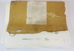
A large collection of Admiralty sea charts, to include Thames Estuary and Great Yarmouth Haven, c.1970's - 1990's, all withdrawn from service.
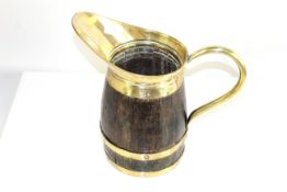
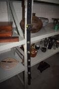
A large brass bound wooden ale pitcher
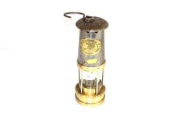
A Thomas & Williams miner's lamp from Aberdeen, Wales, No.144490
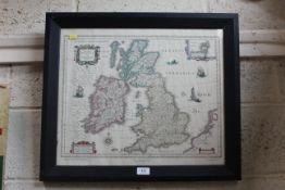
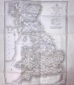
A framed and glazed map of the United Kingdom dated 1635
Five bells mounted to leather strap.
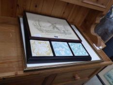
Wall hanging with tiles, a Stevington Mill sketch, plus 2 framed and glazed maps
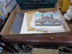
Box of loose book prints and maps
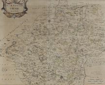
Robert Morden - a late 17th century hand coloured & engraved map of Hertfordshire. Framed and glazed.Measuers approx. 39cm x 48cm.
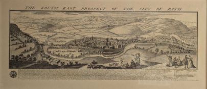
After Nathaniel Buck (1727 - 1753) - The South East Prospect of the City of Bath, engraved map. Framed and glazed.Measuers approx. 43cm x 93cm.
Philosophy and Politics: - Marx, K. & Engels, F. 1959. Manifesto of the Communist Party. Moscow: Foreign Languages Publishing House. A scarce edit...
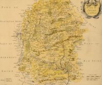
Robert Morden - a late 17th century hand coloured & engraved map of Wiltshire. Framed and glazed.Measuers approx. 52cm x 57cm.
Set of 6 WW2 German Winterhilf Fund Rasing Badges depicting different Types of Ordnance.
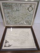
Framed maps of Somerset and The Province of Mounster
Baxter oil print ' Stolen Pleasures' 26x26cm
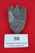
1938 Hesselberg Konventtag badge, eagle over town view, swastika below.
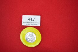
Plastic Fundraising Badge with Religious Medallic Insert – A circular yellow plastic badge with pin-back fitting, inset with a small silvery relie...
European topography:- Halenza, Joseph. c1865 Panorama of the Rhine from Mainz to Coln (Mayence to Cologne), engraved on steel by Frederic Foltz. D...
Maps:- Britain. 1898 Ordnance Survey Map of Somerset County. Surveyed in 1884-86 and published by Major Gen. Sir C. W. Wilson, revised in 1896 and...
Walker, J & C. 1838 A Geological Map of England, Wales and Parts of Scotland, showing also the Inland Navigation with the Railroads and Principal ...
Maps:- Britain. 1889 Ordnance Survey map of Gloucestershire and Wiltshire, five parts. Each engraved map mounted on linen in the orig. cloth cover...
Europe. 1804 A Map of Europe, to which are delineated its Grand Modern Divisions, as well as Partitions into inferior States, Governments &c. Lond...
A LARGE VINTAGE WORLD MAP WALL ART
END OF SALE, THANK YOU FOR YOUR BIDDING. OUR NEXT SALE IS ON THE WEDNESDAY 15TH AND THURSDAY 16TH OCTOBER
A 1960'S MERMAID ALUMINIUM ATKINSON'S ALES BEER TRAY (CLOSED 1962)
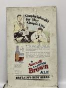
A NEWCASTLE BROWN ALE TIN SIGN, 61CM X 38CM
Edwina Orr (British, b. 1954) Emma, circa 1980sHologramPurchased at MOMA Oxford. Framed & glazedMeasures approx. 63cm x 52cm
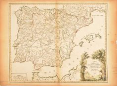
Unframed dated mid 18th century hand coloured engraved map of the Iberian peninsula - 'Carte des Royaumes D'Espagne et de Portugal dans laquelle s...
Large collection of unframed Ordnance Survey maps and charts, to include Langford Court, North Somerset, Cheddar, Ubley, Compton Martin, etc.
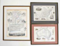
Three 19th century hand coloured maps comprising; 'United States', J & F Tallis, London, Edinburgh, Dublin, 'Australia', engraved by J. Rapkin and...
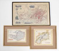
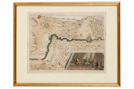
19th century coloured town plan map - 'Clifton and Bristol', with illustrations of well-known Bristol landmarks including the Clifton Observatory,...
Limited Edition Coloured Print Jo Bowen (British, b.1974) edition 64 of 600
Spinnakers - Jo Bowen (British, b.1974) Limited Edition 76/600 - Mounted 41 x 39.5cm
Sailing By The Stars - Jo Bowen (British, b.1974) Limited Edition 99/600 - Mounted 55 x 33cm
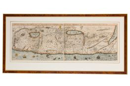
A SET OF ELEVEN 17TH CENTURY MAPS OF THE HOLY LAND FROM THEATRUM TERRAE SANCTAE... the collection of eleven maps and title page from Christian Va...
FIVE 17TH CENTURY HAND COLOURED MAPS OF THE HOLY LAND including the Exodus map from Christian Van Adrichom's Theatrum Terrae Sanctae et biblicaru...
Title: Thomas Leman 1818 Antique 207 Years-Old Map of Roman Roads in Britain.Description: Thomas Leman 1818 Antique 207 Years-Old Map of Roma...
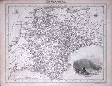
Title: Devonshire Antique Detailed 193 Years-Old Steel-Engraved MapDescription: Devonshire Antique Detailed 193 Years-Old Steel-Engraved MapT...
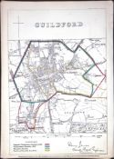
Title: London Guildford Boundary Commission 157-Year-Old Coloured Scarce Antique Map.Description: Original Antique Lithograph Map Taken from ...
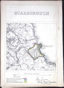
Title: Scarborough Yorkshire Boundary Commission Coloured 157-Year-Old Antique Map.Description: Original Antique Lithograph Map Taken from a ...
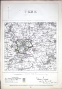
Title: York Yorkshire Boundary Commission 157-Year-Old Coloured Scarce Antique Map.Description: Original Antique Lithograph Map Taken from a ...
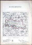
Title: Richmond Yorkshire Boundary Commission Coloured 157-Year-Old Antique Map.Description: Original Antique Lithograph Map Taken from a Fir...
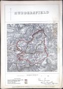
Title: Huddersfield Yorkshire Boundary Commission 157-Year-Old Coloured Antique Map.Description: Original Antique Lithograph Map Taken from a...
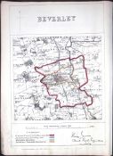
Title: Beverley Yorkshire Boundary Commission Coloured 157-Year-Old Antique Map.Description: Original Antique Lithograph Map Taken from a Fir...
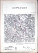
Title: Dewsbury Yorkshire Boundary Commission 157-Year-Old Scarce Antique Map.Description: Original Antique Lithograph Map Taken from a First...
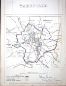
Title: Wakefield Yorkshire Boundary Commission 157-Year-Old Antique Map.Description: Original Antique Lithograph Map Taken from a First Editi...
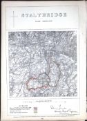
Title: Stalybridge Manchester Boundary Commission Coloured 157-Year-Old Antique Map.Description: Original Antique Lithograph Map Taken from a...
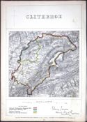
Title: Clitheroe Lancashire Boundary Commission 157-Year-Old Coloured Antique Map.Description: Original Antique Lithograph Map Taken from a F...
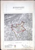
Title: Burnley Lancashire Boundary Commission 157-Year-Old Coloured Antique Map.Description: Original Antique Lithograph Map Taken from a Fir...
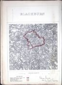
Title: Blackburn Lancashire Boundary Commission 157-Year-Old Antique Map.Description: Original Antique Lithograph Map Taken from a First Edit...
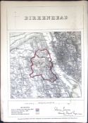
Title: Birkenhead Merseyside Boundary Commission 157-Year-Old Coloured Antique MapDescription: Original Antique Lithograph Map Taken from a F...
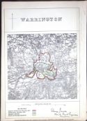
Title: Warrington Lancashire Boundary Commission 157-Year-Old Scarce Antique Map.Description: Original Antique Lithograph Map Taken from a Fi...
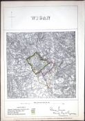
Title: Wigan Lancashire Boundary Commission 157-Year-Old Scarce Antique Map.Description: Original Antique Lithograph Map Taken from a First ...
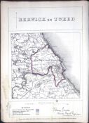
Title: Berwick Upon Tweed Northumberland Boundary Commission 157-Year-Old Antique Map.Description: Original Antique Lithograph Map Taken from...
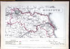
Title: Morpeth Northumberland Boundary Commission 157-Year-Old Antique Map.Description: Original Antique Lithograph Map Taken from a First Ed...
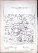
Title: Darlington Durham Boundary Commission 157-Year-Old Antique Map.Description: Original Antique Lithograph Map Taken from a First Edition...
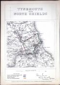
Title: Tynemouth & North Shields Boundary Commission 157-Year-Old Antique Map.Description: Original Antique Lithograph Map Taken from a First...
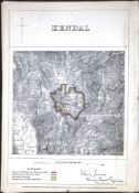
Title: Kendal Lake District Boundary Commission 157-Year-Old Coloured Antique Map.Description: Original Antique Lithograph Map Taken from a F...
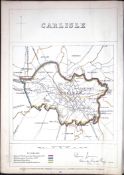
Title: Carlisle Cumbria Boundary Commission 157-Year-Old Coloured Antique Map.Description: Original Antique Lithograph Map Taken from a First...
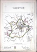
Title: Chester Cheshire Boundary Commission 157-Year-Old Antique Map.Description: Original Antique Lithograph Map Taken from a First Edition ...